sponsor

sponsor

Slider

EmadAbduallah. Theme images by kelvinjay. Powered by Blogger.

Recent Tube

Business

Technology

Life & style

Games

Sports

Fashion

Birds of Ras Muhammad National Park

Birds of Ras Muhammad National Park

Sinai is considered to be an internationally important migration route for the birds especially Soaring birds. This is because the geographical oddity of the area as its located between two continents and two seas, it serves as a land bridge for those migrating birds which do not cross Mediterranean and Red seas in a wide front. Most of Raptors and White storks choose to continue toward South Sinai to cross the sea water.

 In autumn migration, Ras Mohammed is considered as an autumn migration bottle-neck for soaring birds. Migration of White storks from Euroasia toward Africa, pass through South Sinai every year taking Ras Mohammed as stop-over  point, waves of the stork aggregate to rest and to feed in the area.

Raptors are common migrant to the area.

The autumn migration started on the mid. of September continue tell the first of November, and the spring is between Mid of March and May.

Importance of the place

1. It is confirmed that Ras Mohammed is highly important White Stork stop-over site during autumn migration. This is already stated in Important Bird Area Directory for Egypt. The current study offers new data on numbers and behavior of White Stork in the area.
2. It is not confirmed that there are important White Stork migration routes between Ras Mohammed and El-Tur. It must be considered, however, that research effort for this territory was limited.
3. Migration along the Gulf of Aqaba is limited primarily to wader species. No passage of White Stork recorded there.
4. The highest bird diversity was found at Sharm Farm
 

NABQ (Managed Resources Protected Area)

NABQ

(Managed Resources Protected Area)


·    Protectorate name derived from the plural Arabic word "Nebak" which nominate coastal sand dunes, one of common land features in Nabq coastal zone.

Nabq Occupancy

·         Nabq protected area occupies the area between Sharm El Sheikh – Dahab road at the west and the coastline of the southern part of Gulf of Aqaba at the east in addition to a marine zone of 5 Km width starting from South protectorate borders to the north of Dahab City. Nabq occupies a total area of 586 Km2 (464.6 km2 of land and 121.9 Km2 of the sea).

Protected Area Ecosystems

·        There are several ecosystems in Nabq either terrestrial, coastal or marine. Starting from higher altitudes with high granite mountains (maximum 1070 meters) with freshwater catchments, oasis, valleys, vegetated inland sand dunes, vegetated coastal sand dunes, coastal mud and salt flats, mangrove, seagrass, coral reefs and deep water down to more than 1100 meters.
·   The uniqueness of Nabq protected area is so far exceeding the various ecosystems to an exceptional integrity of these ecosystems, no barriers or any source of disturbance is isolating one or more of these ecosystems what means proper supporting of various forms of life.

Justification of Declaration

·         Nabq is an important component of Gulf of Aqaba protected area network, diverse virgin and highly integral ecosystems in addition to highly important and fragile ecosystems  are the major factor  

Local Community (Bedouins)

El Sheikh 3otaik

·         The local community in Southern Sinai are broken down into 8 tribes two main tribes which are Mezeina and Tarabin are inhabiting Sharm El Sheikh, Dahab, Nuweiba and Taba cities in addition to Nabq and Abu Gallum protected areas.
·         Bedouins have traditionally occupied Sinai Peninsula including protected areas retaining their traditional rights and continue to occupy their settlements, fishing, grazing were regulated to balance between maintaining their sources of income and conservation of natural resources. All activities that are likely to damage habitats or reduce biodiversity are now regulated by EEAA staff in co-operation with Bedouin, several Bedouins are now employed in EEAA to work as Rangers to assist in management and conservation activities in protected areas.
·         Bedouin culture has been on strict tribal laws and traditions. Nature is respected, water is consumed sparingly, small water reservoirs are constructed on hillsides to assist wildlife, the relationship between coral reefs, mangroves and fisheries are clearly understood and no damage is allowed. Tribal law prohibits cutting of "green trees", a penalty could be up to three of 2 years old camels or their equivalent value. A common say acting as a rule "killing a tree is like killing a soul". Much can be learned from their statements and protected areas help in driving more of local communities toward more sustainable activities and practices.
·         When decide to explore or have photos in a Bedouin village, please ask for a prior arrangement with your tour guide or park guards to prepare for that as respecting their conservative traditions.       

Mangrove


·         Mangrove forest in Nabq is stretched as a discontinuously along 14 Km of Protected area coast along Gulf of Aqaba mainly in front of the alluvial fan of Wadi Kid covering an area of 50.09 hectares, Nabq mangrove is a single species "Avicennia marina" is considered as the northernmost mangrove in the Red Sea and Indo-pacific region. The occurrence of mangrove in Nabq is encouraged by the seasonal rain flush from supplying Wadi.
·         Mangrove ecosystem is invaluable especially when present along the coast of poor sea lacking nutrients, hence the exported organic nutrients from mangrove ecosystem acting as a single source of nutrients which are exported to other neighboring marine ecosystems like coral reefs.
·         Mangrove with its exceptional growth form and dense aerial roots surrounding is a good buffer regulating actions between land and sea, erosion results from wave and current action is controlled, while sediments with runoff from land are trapped in mangrove what stabilize the shoreline and isolating underground water from escaping festally to the sea.
·         The high capacity of mangrove ecosystem to accumulate carbon either in trees or in the soil is of highly global importance in mitigation of elevated levels of atmospheric carbon dioxide mostly exceeding other adjacent the seagrass ecosystem.
·         Careful examination of the root system will reveal a profusion of snails, crabs, algae, larval fish, shrimp, bivalves and other several species.

Coral Reef


·         Tectonic formation of Gulf of Aqaba provided diverse forms of shoreline and sea profiles, the cost may starts with shallow reef flat extends to several hundred meters or up to more than a kilometer before getting to deeper water as south to Ghraquana village or may be too narrow or totally no reef flat as in the northern part of Nabq (closed area) where the high granite mountains meets the sea.
·         Next to reef may be either shallow sandy bottom with dense seagrass and scattered coral patches of different sizes or steep slope to deeper water and moreover reef walls may begin from the reef edge deep to several meters depth. Several lagoons are present along the coast of Nabq, some are surrounded by mangrove trees as in Gharquana, Rowaissyia, Monquatea lagoons while, others are in reef lagoons of different sizes and depths ranged from less than one meter to more than 7 meters depth, these lagoons are nursery ground support several types juvenile fishes.
·         Diverse sea profile results in support of various types of coral species, so large massive corals like brain corals which are rare in Sharm El Sheikh and Ras Mohammed are common with large sizes in Nabq. Unique underwater coral reef formations adding enjoying experience for diving and snorkeling. 
·         A total of 208 species of hard corals, 119 species of soft corals, 7 seagrass species and about 20 of the world threatened species are in Nabq including Dugong "Seacow", green turtles, Napoleon fish in addition to other terrestrial species.   [sb4] 

Terrestrial Ecosystems


Flora of Nabq

·         Nabq contains 134 plant species of which 86 are perennial, so off-track driving is prohibited to conserve important floristic communities like Salvadora persica, in Arabic "Arak[sb5] ", which spans over an area of about 36 Km2 stabilizing soil and supporting lives of several species, some are endangered like Gazelle which feeds on plant leaves and fruits.   


ABU GALLUM (Managed Resources Protected Area)

ABU GALLUMManaged Resources Protected Area

Abu Gallum Protected Area was established by the Prime Ministerial Decree no.1511/1992 covering 458 Km2 named “Managed Resources Area” of which 121 km2 sea. After that, this area was extended by Decree no.33/1996 reaching Nuweiba-Taba marine section “Environmental Managed Area”, resulting in increasing the marine area, reaching 856 km2. This section including three main areas with special conservation (Pharaon Island, Fjord Bay and Solar Lake in Taba) as adjacent area.
Abu Gallum contains various coastal and mountain ecosystems that are unique to Gulf of Aqaba. The coral reef is mostly undisturbed with a high diversity of reef fish, whose richness of its flora and fauna is overwhelming. Probably, Abu Gallum is one of the most beautiful protectorates in Egypt, with its high mountains, wades, freshwater springs, picturesque sand dunes, coral reef and gravel alluvial fans; this area hosts about 165 plant species, about 45 of these species can only be seen in Abu Gallum and are unique to this area.

The researcher has suggested that Abu Gallum is a floristic frontier falling under the influence of a tropical climate but having predominantly Mediterranean conditions.
Recent studies conducted by researchers in Abu Gallum Protectorate recorded 162 species of marine macro-invertebrates (Echinoderms, Crustacean and Mollusks) associated with coral reefs, which play an important role in the marine ecosystem balance and vitality.
The reef at Abu Gallum supports an active Bedouin artisanal fishery. Fishermen from Nuweiba and Dahab practice subsistence fishing and supply local restaurants with fish and shellfish products.
The fishery is now regulated by the EEAA to reduce damage to the coral reef. The reef can be viewed at marked, safe access entry points.
Abu Gallum plain is narrow and this protected area plays an important part in regulation land use. It also acts as a buffer zone between land development focal points along the coast, while working to protect the natural resources that form the backbone of the local economy and are a great part of the area's attraction for tourists.
The Protectorate is a sensitive area that receives a high conservation priority. Access to regions without vehicle track systems can only be permitted where marked trails have been prepared. Bedouin guides and camels can be hired if requests and arrangements are made at the ranger house located at the mouth of Wadi Rasasah.
A visitor centre located at the northern boundary of Protectorate. It houses a small audio-visual theatre and displays concentrating on the flora and fauna of the Protectorate. information on dive sites and areas to be avoided. It should be noted the access to the underwater caves at Ras Mamlah is strictly forbidden. This cave system, extending to depths extending 100 meters, is unstable and deadly. Divers have been lost and not recovered from its depths.

Access to Abu Gallum 

There are three entrances leading to tourist attractions and camping areas, the first entrance from Dahab city and the start of the famous Dive site the Blu Hole and enter by camels or walk on foot a distance of 7 km from the sea directly in the shadow of mountains, the second entrance through the Road Wadi Rasasah by four-wheel-drive cars and enjoy safari, show mountains and landscapes 35 km  in Wadi and the last entrance through the coastal road from Nuweiba 50 km through the most protected landmarks to camping areas and Bedouin communities.
 Tourist attractions
Blu Hole
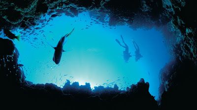
Blue Hole is the most important and beautiful dive sites all over Egypt and is characterised by the presence of biological diversity in ornamental fish and coral reef Habitats, there is also a great diversity in caves underwater at different depths attract lovers of diving adventures.
The site is easily accessible to its proximity to Dahab city attracts fans of professional freediving and scuba diving and snorkelling, Depth up near the beach about 100 meters so it is held by many free diving competitions sport.
AL-Dahayla Village
This is one of the most important tourism regions in Abu Galum protected area, the local communities of Bedouin inhabiting this village and one of the camping areas for tourists and there is ancient nomadic life associated with the culture and heritage of the local community of crafts, handicrafts and provides the local population with food and drinks to visitors. It also features a place of high biodiversity of coral reefs and ornamental fish which are still virgin and watch Napoleon fish and endangered sea turtles in dive sites.

Blue Laguna
Is one of the hottest areas attract visitors in Abu Galoum Protectorate. Quiet, and is considered an aesthetic view featured a camping area.
Blue Laguna is considered a natural shelter for fish fry shelter in which to mature and go out to the open water. Where you can practice water sports that rely on the wind.
Wadi El-Okdah
It is one of the largest and most important Wadies and has a large reserve of flora and wildlife diversity. It has a okdah well which is the most important sources of drinking water for the local community and has its many fresh water wells and dams in Wadi.

Turtle Release in Ras Muhammad National Park


في إيطار جهود الإدارة العامة لمحميات سيناء في حماية الأنواع المهددة بالانقراض بالتعاون مع الجهات المختلفة فقد قامت الإدارة العامة لمحميات سيناء بنفل سلحفاة مصابة من النوع صقرية المنقار الي العيادة البيطرية بمركز دولفينا بمدينة شرم الشيخ وذلك لعلاجها بمعرفة الأطباء البيطريين بالمركز لمدة أربعة أيام حتي استعادة السلحفاة كامل صحتها بعد متابعة دقيقة من قبل كلاً من السيد الدكتور/ خالد علام – مير عام محميات سيناء – والسيد الأستاذ/ وجدي سعد – مالك شركة دولفينا – ولفيف من خبراء المحميات, حيث تم يوم الخميس الموافق 3/11/2016 إطلاق السلحفاة بمنطقة المخيمات بمحمية رأس محمد وتحت رعاية السيد اللواء/ محمود السولية – رئيس مجلس مدينة شرم الشيخ وفي ظل وجود العديد من رواد المحمية الذين رحبوا بشدة تلك الجهود وحرصوا علي التقاط صور تذكارية مع السلحفاة أثناء اطلاقها. ومن المعروف أن السلحفاة صقرية المنقار مصنفة ضمن الكائنات المهددة بالانقراض والمدرجة بالمعاهدة الدولية لحماية الإتجار في الكائنات المهددة بالانقراض  (CITES) والاتحاد الدولي لصون الطبيعة (IUCN) وتصنيفها ضمن الكائنات المجرم صيدها والاتجار فيها دولياً نظراً لقلة اعدادها وزيادة المخاطر الشديدة التي تواجهها من الصيادين او الملوثات وخلافه والتي تسبب نقص كبير لأعدادها على مستوي العالم مما يسبب خطر شديد على تلك الانواع بشكل خاص وعلى البيئة البحرية بشكل عام نظراً لدورها الكبير في الحفاظ علي توازن النظام البيئي البحري مما يعكس اهميتها وضرورة الحفاظ عليها بجانب تجريم ومنع صيدها طبقاً لقانون المحميات الطبيعية رقم 102 لسنة 1983 وقانون البيئة رقم 4 لسنة 1994 والمعدل بالقانون رقم 9 لسنة 2009.

Saint Katherine

Saint Katherine

 
 In 1996, Prime Ministerial Decree No. 940 formally declared the St Katherine Protectorate; full protected-area status was given to approximately 4,350km² of largely mountainous terrain in South Sinai. The area includes Gebel Katherina (Mount Saint Katherine) which is the country’s highest summit at 2,641m. and contains a unique assemblage of natural resources, notably high altitude ecosystems with surprisingly diverse fauna and flora and with a significant proportion of endemic species. The protectorate also includes the world-renowned Mount Sinai (Gebel Musa), where Moses has received the Ten Commandments and the Monastery of Saint Katherine, which one of the oldest functional Christian monasteries in the world.


The 641km² area, within the Protectorate core has been inscribed as a World Heritage Site (WHS) by UNESCO; such sites are recognised for their universal and outstanding values, which must be protected for future generations.


Coral Reef


What is a Coral Reef?


Coral reefs are the most diverse communities on the planet. These tropical marine communities occupy less than 1% of the ocean floor but are inhabited by at least 25% of all marine species. Scientists estimate that more than 25,000 described species from thirty-two of the world’s thirty-three animal phyla live in reef habitats four times the number of animal phyla found in tropical rain forests.


They are the result of a remarkable relationship between coral animals, known as polyps, and microscopic algae (Zooxanthellae) living in the coral tissues. The polyp resembling a tiny sea anemone is able to feed itself, using stinging cells found on its tentacles which paralyzed passing plankton that they feed upon. This plankton supplies only a small part of the nutritional requirements of the coral. The remainder comes from the microscopic algae that convert sunlight, carbon dioxide and their own wastes into oxygen and carbohydrates (photosynthesis). The carbohydrate is also used by the coral polyp to produce the calcium carbonate skeleton (calcification process). This forms the skeleton of the tiny coral polyp and eventually of a coral colony and the structure of what we recognize today as a coral reef.

      More than 200 species of reef-building coral (Hard coral) have been recorded on the reefs of South Sinai.